Understanding Jeepney Route Signs in Manila: Manila Transportation Guide
Introduction
For first-time visitors, even seasoned travelers, jeepney route signs in Manila can look confusing, overwhelming, or completely unreadable at first glance. Jeepneys remain the backbone of Metro Manila’s public transportation system, serving millions of commuters daily. Unlike trains or buses with standardized route maps, jeepneys rely heavily on handwritten or printed route signs displayed on the vehicle itself.
Understanding these route signs is essential if you want to move around Manila efficiently, avoid unnecessary transfers, and ride like a local. This guide explains how jeepney route signs work, what common abbreviations mean, how to read destinations and landmarks, and practical tips to ensure you get on the correct jeepney every time.
By the end of this article, you will be able to decode jeepney signs with confidence and navigate Manila’s streets more smoothly.
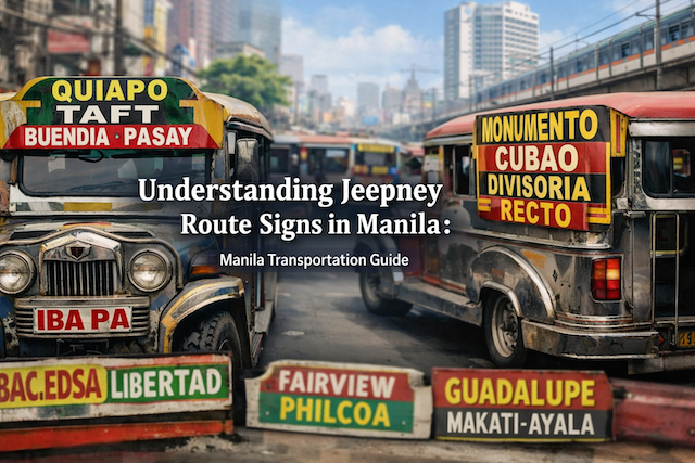
What Are Jeepney Route Signs?
Jeepney route signs are visual indicators displayed on the front windshield, side panels, or roof of a jeepney. They show the primary route, key destinations, and sometimes intermediate stops that the jeepney passes through.
Unlike formal transit systems, jeepney routes are not always fixed down to every street. Instead, route signs usually highlight major roads, districts, terminals, or well-known landmarks. Drivers and conductors expect passengers to understand these references.
Route signs can appear as:
-
Painted metal plates
-
Cardboard signs behind the windshield
-
Plastic boards clipped to the side
-
LED signs on newer jeepneys (rare but increasing)
Where to Look for Jeepney Route Signs
Front Windshield
The most important route sign is usually placed at the top or bottom of the windshield. This sign shows the main route endpoints, often separated by a dash (for example: Quiapo – Cubao).
Side Panels
Many jeepneys list additional destinations on the side of the vehicle. These are useful for confirming whether the jeepney passes through your intended area.
Roof or Bumper Area
Some jeepneys place destination boards above the windshield or near the bumper, especially older models.
Because signage styles vary widely, it is common to check multiple locations on the jeepney before boarding.
Understanding Route Endpoints
What Are Route Endpoints?
Route endpoints are the starting and ending areas of the jeepney’s regular route. They are usually major districts, transport hubs, or terminals.
Examples of common endpoints include:
-
Divisoria
-
Quiapo
-
Cubao
-
Taft
-
Baclaran
-
Monumento
-
Pasay Rotonda
If your destination lies anywhere between these endpoints, the jeepney is likely suitable.
How Destinations Are Listed on Jeepney Signs
Order Does Not Always Mean Direction
Unlike train lines, the order of destinations on a jeepney sign does not always indicate travel direction. The sign often shows both endpoints regardless of which direction the jeepney is currently heading.
To confirm direction:
Multiple Destinations on One Sign
A single jeepney sign can list many places. These usually represent major streets, intersections, or landmarks along the route.
For example:
Taft – UN – Pedro Gil – Quirino
This indicates that the jeepney travels along Taft Avenue and passes those stations or areas.
Common Abbreviations on Jeepney Route Signs
Jeepney signs often use abbreviations due to limited space. Learning these abbreviations is key to understanding routes quickly.
Street and Avenue Abbreviations
-
Ave – Avenue
-
Blvd – Boulevard
-
Rd – Road
-
Ext – Extension
Example:
Roxas Blvd refers to Roxas Boulevard.
District and Landmark Shortcuts
Example:
Sta. Mesa means Santa Mesa.
Transport Hubs and Institutions
-
LRT – Light Rail Transit station
-
MRT – Metro Rail Transit station
-
PNR – Philippine National Railways
-
UST – University of Santo Tomas
-
UE – University of the East
These abbreviations are extremely common and helpful for navigation.
Understanding Landmark-Based Routes
Why Landmarks Matter
Jeepney routes rely heavily on landmarks rather than exact street addresses. Locals often think in terms of malls, schools, churches, and terminals.
Common landmarks include:
If you know a nearby landmark to your destination, you can often find a jeepney that passes close enough.
Major Roads Commonly Seen on Jeepney Signs
Recognizing major roads helps you immediately understand where a jeepney is going.
Some of the most common roads include:
-
EDSA – The main circumferential road of Metro Manila
-
Taft – Taft Avenue, running through Manila and Pasay
-
España – España Boulevard, near universities
-
Rizal Ave – Also known as Avenida
-
Quezon Ave – Major road in Quezon City
-
Aurora Blvd – Runs through Cubao and nearby areas
If your destination is near one of these roads, choosing a jeepney with that road name is often sufficient.
Reading Directional Variations
Same Route, Different Direction
A jeepney with the same route name may operate in both directions. For example:
-
Cubao – Divisoria
-
Divisoria – Cubao
Both signs exist, but not all jeepneys update signs when changing direction. This is why asking is important.
Short Routes vs Full Routes
Some jeepneys operate shortened versions of a longer route. These often include words like:
Example:
Cubao – Rosario via Ortigas
This tells you the jeepney uses Ortigas Avenue instead of another road.
Color-Coding and Paint Styles
Unlike buses, jeepneys are not fully standardized by color. However, jeepneys from the same route often share similar paint schemes because they belong to the same operator group.
That said:
Asking for Confirmation: A Normal Practice
Even locals regularly ask drivers or conductors for confirmation. This is normal and expected.
Useful phrases include:
Drivers are generally helpful, especially if you ask politely.
Understanding “Via” on Route Signs
The word via indicates the specific road or area the jeepney passes through.
Example:
Quiapo – Cubao via España
This tells you the jeepney uses España Boulevard, not an alternative route like Aurora Boulevard.
If your destination is on a specific road, always look for the “via” indicator.
Route Signs vs Actual Drop-Off Points
Jeepney signs list major points, not every possible stop. You can usually ask to be dropped off anywhere along the route, as long as it is safe and legal to stop.
Common practice:
Common Mistakes When Reading Jeepney Route Signs
Assuming the Sign Lists All Stops
It does not. The sign shows only major points.
Ignoring Direction
Always confirm direction, especially on long routes.
Confusing Similar Place Names
Some areas share similar names (for example, multiple streets named Rizal). Context matters.
Practical Tips for First-Time Jeepney Riders
Use Maps as Backup
Apps like Google Maps can help identify major roads and landmarks that match jeepney signs.
Learn Key Hubs First
Familiarize yourself with major hubs such as Cubao, Quiapo, Taft, and Monumento. Many routes connect to these points.
Combine Jeepneys with Trains
Jeepneys often connect to MRT and LRT stations. Look for signs mentioning those stations.
Do Not Hesitate to Ask
Asking saves time and prevents wrong rides.
Are Jeepney Route Signs Becoming More Standardized?
With the introduction of modern jeepneys, some routes now use LED signs and clearer destination boards. However, traditional jeepneys remain widespread, and their route signs continue to follow informal conventions.
For now, learning to read classic jeepney signs remains an essential skill in Manila.
Conclusion
Jeepney route signs in Manila may seem chaotic at first, but they follow practical logic rooted in local commuting culture. By understanding route endpoints, common abbreviations, landmark-based navigation, and directional cues, you can confidently ride jeepneys without confusion.
Mastering jeepney route signs is more than just a transportation skill. It is a gateway to experiencing Manila like a local, saving money, and exploring the city with flexibility and confidence.
With practice, what once looked like a jumble of words will quickly become a familiar and reliable guide through Metro Manila’s streets.
Frequently Asked Questions (FAQs)
Why do jeepney route signs look inconsistent compared to buses or trains?
Jeepney signage is largely operator-driven rather than controlled by a single central transit authority. Many jeepneys are owned by small operators or drivers who follow traditional practices, so signs may be handwritten, painted, printed on boards, or displayed in different positions on the vehicle. Routes can also have minor variations depending on traffic rules, road closures, or terminal instructions. Because of this, two jeepneys serving the “same” route might show slightly different destination lists. The safest approach is to treat the sign as a summary of major areas and then confirm your exact destination by asking the driver or conductor if the jeepney will pass your stop.
What are “endpoints” on a jeepney route sign, and why are they important?
Endpoints are the main start and end areas of a jeepney’s regular route. They are usually major districts, terminals, or well-known transport hubs such as Quiapo, Divisoria, Cubao, Taft, Baclaran, Monumento, or Pasay Rotonda. Endpoints matter because they tell you the general corridor the jeepney travels. If your destination lies between those endpoints, the jeepney is likely a good match even if your exact street or landmark is not listed. Endpoints also help you avoid taking a jeepney that is heading in the opposite direction, especially when a sign shows both ends of the route without indicating which way the vehicle is currently going.
What does “via” mean on jeepney route signs?
“Via” tells you which road or area the jeepney uses as its main path. For example, “Quiapo – Cubao via España” indicates the jeepney travels through España Boulevard rather than an alternate corridor. This is especially useful when multiple routes share the same endpoints but follow different major roads. If your destination is located along a specific avenue, looking for “via” can prevent you from boarding a jeepney that technically connects the same endpoints but takes a different route. When you see “via,” treat it like the route’s “core road” and compare it to the major road closest to your destination.
Why do some jeepney signs list many places, while others list only two?
Some jeepney operators keep signage simple by listing only the two main endpoints. Others add intermediate districts, major streets, universities, or landmark stops to help passengers identify the corridor more clearly. A sign with many places does not necessarily mean the route is longer; it often reflects the operator’s preference or local demand. In busy areas, adding well-known points (such as a university, hospital, or shopping center) can attract more riders. If you only see two destinations, you can still ride confidently by confirming the main road the jeepney follows and asking if it will pass your target area.
Are jeepney signs reliable for direction, or do they show both directions?
Many jeepney signs display both endpoints regardless of direction, so you cannot assume the jeepney is heading toward the first place listed. This happens because drivers reuse signs on the return trip, or because the signage is meant to represent the full route rather than the current direction. Direction can also change at terminals or turning points that are not obvious to visitors. To confirm direction, check where you are standing relative to the endpoints, watch the jeepney’s traffic flow, and ask a quick question like, “Pa-___ po?” or “Dadaan po ba sa ___?” This habit is normal even for locals.
What are common abbreviations I should learn to read jeepney signs faster?
Abbreviations are used because space is limited. Common ones include “Ave” (Avenue), “Blvd” (Boulevard), “Rd” (Road), and “Ext” (Extension). You may also see “Sta.” (Santa), “Sto.” (Santo), “Gen.” (General), or shortened district names. Transit-related abbreviations like “LRT,” “MRT,” and “PNR” can help you connect jeepneys with train stations. Schools and institutions may appear as “UST” (University of Santo Tomas) or other familiar initials. If you are unsure, treat abbreviations as hints and confirm with the driver using a nearby landmark name.
How do I use landmarks to interpret jeepney routes if my exact address is not listed?
Jeepney travel in Manila often works best by landmarks rather than street numbers. Identify a major landmark near your destination such as a mall, university, church, hospital, or a famous intersection. Then look for that landmark or the nearest major road on the jeepney sign. If the landmark is not listed, choose a jeepney that clearly passes along the correct corridor and ask the driver if they pass near your landmark. When requesting a stop, you can also say the landmark name instead of a street name. This approach reduces confusion because many drivers think in terms of popular reference points rather than exact addresses.
What should I do if the sign is unclear or blocked by glare, stickers, or decorations?
If the sign is hard to read, do not guess. Step closer (safely) to check the windshield and side signage, and listen for conductors calling out destinations. If it is still unclear, ask directly before boarding. A quick question can save you time and prevent a long detour. You can also compare with nearby jeepneys parked in the same area, because routes often cluster near terminals. If you are in a busy spot like a station area, look for a line of jeepneys that share similar route boards and verify with a local passenger or a nearby vendor who often knows the common routes in that area.
Do modern jeepneys have easier route signs?
Some modern or “new generation” jeepneys use clearer printed boards or LED displays, which can be easier to read at a distance. However, traditional jeepneys remain widespread, and signage standards are still mixed. Even with modern signage, route variations and local landmark-based navigation still apply. You should still confirm direction and whether the vehicle passes your exact stop. Think of modern signs as slightly more readable, not fully standardized like subway systems. Learning the logic behind routes—endpoints, major roads, and landmarks—will help you regardless of vehicle type.
How can I confirm I am boarding the correct jeepney without slowing down the line?
Keep your question short and specific. Instead of asking a long explanation, ask about your key destination: “Dadaan po ba sa ___?” or “Pa-___ po?” If you know the major road, ask about that road name. Stand to the side so you are not blocking other passengers. If you are unsure between two similar routes, ask the driver which road they take (for example, “via España?”). This quick confirmation is normal and does not inconvenience drivers. Many drivers prefer a passenger to ask rather than ride the wrong route and request unexpected drop-offs.
What is the best way to avoid getting lost if I accidentally take the wrong jeepney?
If you suspect you are on the wrong route, get off at a safe, busy area such as a major intersection, mall area, or near a train station. Use your phone map to identify where you are, then choose a corrective option: transfer to another jeepney, ride a train, or switch to a taxi or ride-hailing service if needed. Avoid panicking—Metro Manila routes overlap heavily, and there is almost always another transport option nearby. When in doubt, ask a local vendor, security guard, or station staff for the best way to return to your intended corridor.